About - This Station


Weather station

Davis Vp2 6163

Davis Vantage Pro 2 Plus, ISS sensor suite, Solar, UV, Anemometer

41.43 S

148.27 E

18 m
The thermometer and humidity sensor are 1.2m above the ground, the wind sensor is connected wirelessly to the main console and is 1.2m above the roof and 9m above ground level.
In operation since : 01 November 2019 ( 01-11-2019 )
Console - 3 C-cells batteries, sensors 2 - 1.2 Volt NiCad C-cells
2000 records
Temperature: every 30s
Wind: every 10s
Haydes NUC, Win10
ASUS RT-AC5300, Telstra NbN Fixed Wireless
BeaumarisWX - Beaumaris Weather Tasmania Australia
Roof Mounted 4K HKVision High Resolution Bullet, facing East by South looking over the Tasman Sea towards New Zealand : Live Webcam and Daily Time-Lapse


Inside Temperature (sensor located in console)
Resolution and Units : Current Data: 0.1°F or 1°F or 0.1°C or 1°C (user-selectable)
Historical Data and Alarms : 1°F or 1°C (user-selectable)
Range : +32° to +140°F (0° to +60°C)
Wireless Vantage Pro and Vantage Pro Plus Stations, 3
VANTAGE PRO
Sensor Accuracy : ±1°F (±0.5°C) up to 110°F (43°C), ±2°F (±1°C) over 110°F (43°C)
Update Interval : 1 minute
Current Data : Instant Reading (user adjustable); Daily and Monthly High and Low
Historical Data : Hourly Readings; Daily and Monthly Highs and Lows
Alarms : High and Low Thresholds from Instant Reading
Inside Relative Humidity (sensor located in console)
Range : 0 to 90% RH
Accuracy : #177;5%
Update Interval : 1 minute
Current Data : nstant (user adjustable) and Hourly Reading; Daily, Monthly High and Low
Historical Data : Hourly Readings; Daily, Monthly Highs and Lows
Alarms : High and Low Threshold from Instant Reading
Outside Temperature (sensor located in ISS)
Resolution and Units : Current Data: 0.1°F or 1°F or 0.1°C or 1°C (user-selectable) nominal
Historical Data and Alarms: 1°F or 1°C (user-selectable)
Range : -40° to +150°F (-40° to +65°C)
Sensor Accuracy : ±1°F (±0.5°C) up to 110°F (43°C), ±2°F (±1°C) over 110°F (43°C)
Radiation Induced Error (Passive Shield) : +4°F (2°C) at solar noon (insolation = 1040 W/m2
, avg. wind speed = 2 mph
(1 m/s)) (reference: RM Young Model 43408 Fan-Aspirated Radiation
Shield)
Radiation Induced Error (Fan-Aspirated) : +0.6°F (0.3°C) at solar noon (insolation = 1040 W/m2
, avg. wind speed = 2
mph (1 m/s)) (reference: RM Young Model 43408 Fan-Aspirated Radiation
Shield)
Update Interval : 10 to 12 seconds
Current Data : Instant Reading (user adjustable); Daily, Monthly, Yearly High and Low
Historical Data : Hourly Readings; Daily, Monthly, Yearly Highs and Lows
Alarms : High and Low Thresholds from Instant Reading
Outside Relative Humidity (sensor located in ISS)
Range : 1 to 100% RH
Accuracy : ±3% (0 to 90% RH), ±4% (90 to 100% RH)
Temperature Coefficient : 0.03% per °F (0.05% per °C), reference 68°F (20°C)
Drift : ±0.5% per year
Update Interval : 50 seconds to 1 minute
Current Data : Instant (user adjustable) and Hourly Reading; Daily, Monthly High and Low
Historical Data : Hourly Readings; Daily, Monthly Highs and Lows
Alarms : High and Low Threshold from Instant Reading
Barometric Pressure (sensor located in console)
Resolution and Units : 0.01" Hg, 0.1 mm Hg, 0.1 hPa/mb (user-selectable)
Corrected Range : 26.00" to 32.00" Hg, 660.0 to 810.0 mm Hg, 880.0 to 1080.0 hPa/mb
Uncorrected Range : 18.00" to 33.50" Hg, 457.0 to 850.0 mm Hg, 592.0 to 1130.0 hPa/mb
Elevation Range : -999’ to +12,500’ (-305 m to 3810 m)
Uncorrected Reading Accuracy : ±0.03" Hg (±0.8 mm Hg, ±1.0 hPa/mb) (at room temperature)
Sea-Level Reduction Equation Used : United States Method employed prior to use of current "R Factor" method
Equation Source : Smithsonian Meteorological Tables
Equation Accuracy : ±0.01" Hg (±0.3 mm Hg, ±0.3 hPa/mb)
Elevation Accuracy Required : ±10’ (3m) to meet equation accuracy specification
Overall Accuracy : ±0.04" Hg (±1.0 mm Hg, ±1.4 hPa/mb)
Trend (change in 3 hours) : Change Š0.6" (2 hPa/mb, 1.5 mm Hg) = Rapidly
Change Š0.2" (.7hPa/mb, .5 mm Hg)= Slowly
Trend Indication : 5 position arrow: Rising (rapidly or slowly), Steady, or Falling (rapidly or
slowly)
Update Interval : 15 minutes or when console BAR key is pressed twice
Current Data : Instant, 15-min., and Hourly Reading; Daily, Monthly, High and Low
Historical Data : 15-min. and Hourly Reading; Daily, Monthly Highs and Lows
Alarms : High Threshold from Current Trend for Storm Clearing (Rising Trend
Low Threshold from Current Trend for Storm Warning (Falling Trend)
Range for Rising and Falling Trend Alarms : 0.01 to 0.25" Hg (0.1 to 6.4 mm Hg, 0.1 to 8.5 hPa/mb )
Wind Speed
Resolution and Units : 1 mph, 1 km/h, 0.1 m/s, or 1 knot (user-selectable)
Range (large wind cups) : 2 to 150 mph, 2 to 130 knots, 1 to 67 m/s, 3 to 241 km/h
Range (small wind cups) : 3 to 175 mph, 3 to 150 knots, 1.5 to 79 m/s, 5 to 282 km/h
Update Interval : Instant Reading: 2.5 to 3 seconds, 10-minute Average: 1 minute
Accuracy (large wind cups) : ±2 mph (2 kts, 3 km/h, 1 m/s) or ±5%, whichever is greater
Accuracy (small wind cups) : ±3 mph (3 kts, 5 km/h, 1.5 m/s) or ±5%, whichever is greater
Maximum Cable Length : 540’ (165 m)
Current Data : Instant Reading; 10-minute and Hourly Average; Hourly High; Daily,
Monthly and Yearly High with Direction of High
Historical Data : 10-min. and Hourly Averages; Hourly Highs; Daily, Monthly and Yearly
Highs with Direction of Highs
Alarms : igh Thresholds from Instant Reading and 10-minute Average
Wind Direction
Display Resolution : 16 points (22.5°) on compass rose, 1° in numeric display
Accuracy : ±7°
Update Interval : 2.5 to 3 seconds
Current Data : Instant Reading (user adjustable); 10-min. Dominant; Hourly, Daily,
Monthly Dominant
Historical Data : Past 6 10-min. Dominants on compass rose only; Hourly, Daily, Monthly
Dominants
Rainfall
Resolution and Units : 0.01" or 0.25 mm (user-selectable) (1 mm at totals = 2000 mm)
Daily/Storm Rainfall Range : 0 to 99.99" (0 to 9999 mm)
Monthly/Yearly/Total Rainfall Range : 0 to 199.99" (0 to 19999 mm)
Rain Rate : 0 to 199.99" (0 to 19999 mm)
Accuracy : For rain rates up to 2"/hr (50 mm/hr): ±4% of total or +0.01" (0.25 mm)
(0.01" = one tip of the bucket), whichever is greater
For rain rates from 2"/hr (50 mm/hr) to 4"/hr (100 mm/hr): ±5% of total or
+0.01" (0.25 mm) (0.01" = one tip of the bucket), whichever is greater
Update Interval : 10 to 12 seconds
Storm Determination Method : 0.02" (0.5 mm) begins a storm event, 24 hours without further
accumlulation ends a storm event
Current Data : Totals for Past 15-min, Past 24-hour, Daily, Monthly, Yearly (start date
user-selectable) and Storm (with begin date); Umbrella is displayed when
15 minute Total exceeds zero
Historical Data : Totals for 15-min, Daily, Monthly, Yearly (start date user-selectable) and
Storm (with begin and end dates)
Alarms : High Threshold from Latest Flash Flood (15-min. Total, default is 0.50",
12.7 mm), 24-hour Total, Storm Total,
Range for Rain Alarms : 0 to 99.99" (0 to 999.7 mm )
Rain Rate
Resolution and Units : 0.01" or 0.25 mm (user-selectable) at typical rates
Range : 0, 0.04"/hr (1 mm/hr) to 100"/hr (0 to 1999.9 mm/hr)
Accuracy : ±5% or ±0.04"/hr (1 mm/hr) (up to 10"/hr. (250 mm/hr.)), whichever is
greater
Update Interval : 10 to 12 seconds
Calculation Method : Measures time between successive tips of rain collector. Elapsed time
greater than 15 minutes or only one tip of the rain collector constitutes a
rain rate of zero.
Current Data : Instant and 1-min. Reading; Hourly, Daily, Monthly and Yearly High
Historical Data : 1-min Reading; Hourly, Daily, Monthly and Yearly Highs
Alarm : High Threshold from Instant Reading
Resolution and Units : 1 W/m2 Range : 0 to 1800 W/m2
Accuracy : ±5% of full scale (Reference: Eppley PSP at 1000 W/m2)
Drift : up to ±2% per year
Cosine Reponse : ±3% for angle of incidence from 0° to 75°
Temperature Coefficient : -0.067% per °F (-0.12% per °C); reference temperature = 77°F (25 °C)
Update Interval : 50 seconds to 1 minute (5 minutes when dark)
Current Data : Instant Reading and Hourly Average; Daily, Monthly High
Historical Data : Hourly Average, Daily, Monthly Highs
Alarm : High Threshold from Instant Reading
Ultra Violet (UV) Radiation Index
Resolution and Units : 0.1 Index
Range : 0 to 16 Index
Accuracy : ±5% of full scale (Reference: Yankee UVB-1 at UV index 10 (Extremely
High))
Cosine Reponse : ±4% (0° to 65° incident angle); 9% (65° to 85° incident angle)
Update Interval : 50 seconds to 1 minute (5 minutes when dark)
Current Data : Instant Reading and Hourly Average; Daily, Monthly High
Historical Data : Hourly Average, Daily, Monthly Highs
Alarm : High Threshold from Instant Calculation
Ultra Violet (UV) Radiation Dose
Resolution and Units : 0.1 MEDs to 19.9 MEDs; 1 MED above 19.9 MEDS
Range : 0 to 199 MEDs
Accuracy : ±5% of daily total
Drift : up to ±2% per year
Update Interval : 50 seconds to 1 minute (5 minutes when dark)
Current Data : Latest Daily Total (user resetable at any time from Current Screen)
Historical Data : Hourly, Daily Totals (user reset from Current Screen does not affect these
values)
Alarm : High Threshold from Daily Total
Alarm Range : 0 to 19.9 MED

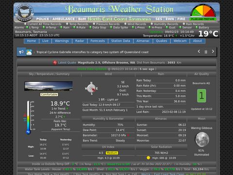
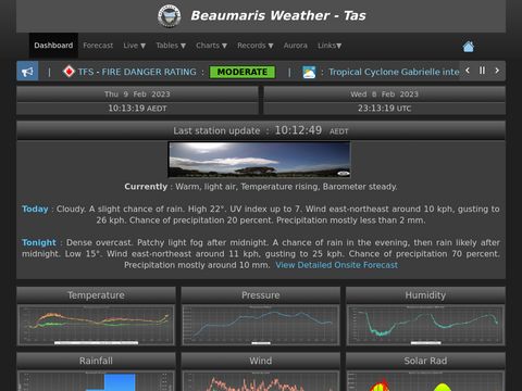
SUMMARY : The station is powered by a Davis Vantage Pro 2 weather station, with a 24 hour Fan Asperated Radiation Shield for better Temperature recording as well as UV and Solar Radiation Sensors and Soil Temperature and Moisture Sensors at 100mm and 400mm depth.

The data is collected every 2.5 seconds and the site is updated every 15 seconds, using CU-MX Software.

The station is comprised of an anemometer, a rain gauge and a thermo-hydro sensor situated in optimal positions for highest accuracy possible.

In addition there is an onsite Purple Air Quality Monitor, also a 4K HKVision Weather Cam that runs 24 hours a day recording and supplying the last 7 Days of 24 Hour Time-Lapse Videos.

In addition Seismic data is also recorded onsite 24 Hours a day using a Raspberry Shake Monitor 4D which is housed in an underground Vault.

In addition we generate onsite weather forecasts up to 7 Days out (every 3 hours and data output is displayed in 30 minute intervals, in Graphical and Text Formats), using WxSim Software Customised specifically for Beaumaris Weather Station. You can read more about Our Onsite Forecasts by clicking here.

This station also sends onsite Observation data 24/7 to (WU - Weather Underground , BoM WOW - Metoffice and Windy.com), to be used for weather analysis and area forecasting.

Active Uploads

Windy Windy - Windy.com - Automatic Weather Observations siteID = Beaumaris - f05d1ef9
We also upload our Weather Webcam to Windy.com, select Webcams on Windy
BoM WOW Metoffice ID=40976642 BoM WOW Metoffice - Automatic Weather Observations siteID = BeaumarisWX - 40976642 ( About BoM WoW ) Info

QR-Code ( Scan with you Mobile Phone and save to your Home Page).

qr codewebsite image Beaumaris Weather Main Desktop version of our Website

qr code mobilewebsite image mobile Beaumaris Weather Main Mobile version of our Website

About - Beaumaris ( This beautiful beach side area )


Beaumaris is a small community with a population of approximately 300 people ( and growing ) on the north-east coast of Tasmania, situated beteween St Helens and Scamander in the Parish of FRAMPTON in the Land District of CORNWALL Tasmania.

Beaumaris is served by the Break O'Day Council - St Helens Tasmania and is principally composed of beach-front properties, many of which are holiday or rental accommodation. The area is known for surfing, beach fishing and beach walking along it's extensive picturesque white sand beaches and turquoise waters.

Beaumaris is a great place to chill out and let nature come to you.

Beaumaris from a local's point of view, is a relaxed coastal town right on the beach where the sound of crashing waves and the smell of sea salt invigorate your soul.

Surfside is the local drinking hole and where locals and visitors alike gather for a great feed, a casual drink or a game of pool.

Beaumaris is 5 minutes from Scamander (pharmacy, fuel, supermarket, post office, take aways) and 12 minutes from St Helens which is the largest town on Tasmania's east coast.

St Helens is home to a hospital, doctors surgery, dental surgery, substantial retail shopping district, great restaurants, school, Medea Park Residential Care nursing home, vet and more.

The township is serviced by a twice daily bus service to the coastal towns and also major cities. 4g Optus and Telstra coverage available plus NbN broadband internet.

Beaumaris Tasmania is named after a small town on the Isle of Anglesey in Wales, it was a former Viking settlement known as PorthyWygyr, with developmental growth traced back to 1295 when Edward I of England, having conquered Wales, commissioned the building of Beaumaris Castle ( Visit Beaumaris Castle )as part of a chain of fortifications around the North Wales coast. In 1939, The Dunlop Rubber Company bought a large area of Beaumaris intending to build a garden city, but was disrupted by war and economic shortages that halted their plans, and so by the early 1950’s Beaumaris was largely undeveloped. The town was however announced as a locality in 1967 after a lengthy span of architectural evolution.

Free Weather Sticker for your Website


You can add a weather graphic to your website, which displays our current onsite weather (updated every 15 seconds) in Beaumaris, NE Coast Tasmania. Just select and copy the HTML code in the yellow box below the weather graphic and paste it into your webpage's HTML editor.

Current weather conditions in Beaumaris, NE Coast Tasmania

<a href="https://beaumaris-weather.com">
<img src="https://beaumaris-weather.com/banner_small.php" 
alt="Current weather conditions in Beaumaris NE Coast Tasmania" 
title="Current weather conditions in Beaumaris NE Coast Tasmania" 
width="580" height="100" /></a>

About - Our Onsite Forecasts


We generate onsite weather forecasts up to 7 Days out (every 3 hours and data output is displayed in 30 minute intervals, in Graphical and Text Formats), using WxSim Software Customised specifically for Beaumaris Weather Station.

These 7 Day weather forecasts are produced by us specifically for the Beaumaris area, but can also be relevant to the surrounding areas within an 80 km radius.

For the purpose of these onsite forecasts, Day forecasts cover the times of 06:00 - 18:00 AEST/AEDT and Night forecasts cover 18:00 - 06:00 AEST/AEDT. For example Monday night is 18:00 Monday to 06:00 Tuesday. Rainfall is calculated as midnight to midnight.

All forecast Times are auto adjusted for DST (Daylight Saving Time).
Data used within WxSim is our own onsite observed weather data as well as a Mix of Data obtained from ( GFS ) Global Forecast System and ( ECMWF ) European Centre for Medium-Range Weather Forecasts.

WXSIM (Weather Simulator) is a powerful, truly one-of-a-kind tool for forecasting, or just plain studying weather. Its primary purpose is providing accurate, detailed forecasts tailored for your specific location, using a combination of imported real-time and model data (from the internet, plus optionally from your home weather station) and its own internal modeling capabilities. It can even improve its forecasts by learning from past results!

Here are some of the ways WXSIM's hundreds of registered users have employed the program over the last 25+ years:
1: Generating forecasts for a home weather station, using its data.
2: Professional forecasts for clients (i.e. for media, agriculture, electrical energy load forecasting, and wind turbines).
3: Forecasting for recreation (i.e. sailing, soaring, and snow skiing).
4: Education, including teaching forecasting skills.
Here are some of the things that WXSIM can forecast (out to 7 Days):
1: Temperature (2 meters above ground, 5 different altitudes above surface, 5 sub-surface depths, at grass surface, plus wind chill factor).
2: Dew point, relative humidity, wet bulb temperature, heat index, and humidex, 2 meters above the surface.
3: Wind speed (and gust strength) and direction 10 meters above the surface, plus wind speed for 2 other heights for wind turbines.
4: Cloud cover and opacity at 5 different heights.
5: Precipitation type and intensity, plus snow depth and ice accumulation (including melting and sublimation).
6: Stability parameters and likelihood of thunderstorms or severe convection.
And much more!

About - This Website


This site is a template design by CarterLake.org with PHP conversion by Saratoga-Weather.org.

Special thanks go to Kevin Reed ( Rest his Soul ) at TNET Weather for his work on the original Carterlake templates, and his design for the common website PHP management.

Special thanks to Mike Challis of Long Beach WA for his wind-rose generator, Theme Switcher and CSS styling help with these templates.

Special thanks go to Ken True of Saratoga-Weather.org for the AJAX conditions display, dashboard and integration of the TNET Weather common PHP site design for this site.

This Template in it's current state, has been heavily modified by Tony ( admin of this station, Beaumaris-Weather.com ).

Special thanks go to Mapantz at Wareham Weather for his assistance with the revamped Monthly Charts page, which now includes Wind Barbs and more.

Special thanks go to Tom Ehrensperger ( Legend ) at WxSim for his continual work on the WxSim Suite of Forecasting Applications.

We also Display Warnings for the Beaumaris Area : Supplied by Willy Weather

We also Display Fire related Incidents, Advice, Alerts and Warnings for the Tasmanian Region : Supplied by Tasmanian Fire Service

We also Display Warnings, Alerts and Global Weather related News : Supplied by Weatherzone

This station uses VentraIP to host our website: if you are having issues, you can view the VentraIP Servers Status here