
-
 : Welcome to Beaumaris Weather |
 -
 : ENSO Outlook ( Current Status ) Inactive by Bureau of Meteorology |
 -

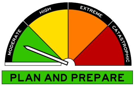
 : Fuel Reduction Smoke Alert - New Ecclestone Road, Riverside - Avoid smoke by TasALERT |
 - : Bushfire Smoke Alert - Bass Highway, Port Latta, Crayfish Creek and surrounds - Avoid smoke by TasALERT |
-
 25/16:05 EST Marine Wind Warning Summary for Tasmania |
 - 25/10:56 EST Cancellation of Warning to Sheep Graziersfor South East forecast district |
-
 : North East Fresh Water - Tasmania : Call Liam or Jon on 0422 195 649 |
 -
 : Satellites capture huge dust storm crossing Mediterranean Sea |
 - : A digger's letter from snowbound Gallipoli |
- : Summery Sydney, wintry Melbourne |
-
 : New weather radar brings increased coverage to Toowoomba and surrounds |
 - : April 16 2024 Climate Driver Update: Tropical Pacific Ocean now ENSO neutral |
- : Bureau of Meteorology's 2024 Autumn Long-Range Forecast |
| |
| Onsite Data Updated: @ 25/04/2024 17:30 - next update at 17:35 | ||||||||||||||||||||||||||||||||||||||||
| Sky / Temperature / Summary | Wind | Rain | Air Quality | |||||||||||||||||||||||||||||||||||||
|
|
|
|
|||||||||||||||||||||||||||||||||||||
| Humidity & Barometer | Almanac | Moon | ||||||||||||||||||||||||||||||||||||||
|
|
|
||||||||||||||||||||||||||||||||||||||
| UV Index | Solar Radiation | |||||||||||||||||||||||||||||||||||||||
|
|
|||||||||||||||||||||||||||||||||||||||


| Australian Extremes | High Temp : 37.6° C | Low Temp : -4.6° C | Precipitation : 46 mm |
| Past 24 hours | Yampi Sound | Cooma Airport Aws | Maningrida Aero |
| Beaumaris Onsite Forecast ( Updated every 3 Hours ) : Last Updated : Thursday, 25-Apr-2024 17:00 AEST | |||
 Beaumaris Onsite Forecast Detail
| Note : Our Onsite Day forecasts cover the times of 06:00 - 18:00 and Night forecasts cover 18:00 - 06:00 | |||||||||||||
|
Next 3hr ( 00z ) Beaumaris Onsite WxSim Re-Forecast due on ( Thu 25 at 20:25 AEST ) WxSim-EUROMIX ( 100 % GFS Run ( 2024-04-25-00 Z ) and 0 % ECMWF Mix Run ( 18 Z )) | |||||||||||||
Tonight : Partly cloudy in the evening, becoming clear after midnight. Cool. Low 6°. Wind southwest around 11 kph, gusting to 26 kph, in the evening, becoming west after midnight. |
|||||||||||||
Friday : Sunny. Patchy light fog in the morning. High 19°. UV index up to 2. Wind west around 5 kph in the morning, becoming north-northeast in the afternoon. |
|||||||||||||
Friday night : Clear. Patchy light fog after midnight. Low 7°. Wind west around 5 kph. |
|||||||||||||
Saturday : Sunny. Patchy light fog in the morning. Mild. High 20°. UV index up to 3. Wind north-northwest around 7 kph, gusting to 24 kph, in the morning, becoming 16 kph, gusting to 33 kph, in the afternoon. |
|||||||||||||
Saturday night : Partly to mostly cloudy. Low 8°. Wind west-northwest around 14 kph, gusting to 29 kph. |
|||||||||||||
Sunday : Partly cloudy in the morning, becoming mostly cloudy to cloudy in the afternoon. High 19°. UV index up to 2. Wind west-northwest around 17 kph, gusting to 33 kph, in the morning, becoming north-northwest in the afternoon. |
|||||||||||||
Sunday night : Partly to mostly cloudy. Breezy. Low 10°. Wind north-northwest around 18 kph, gusting to 32 kph. |
|||||||||||||
Monday : Mostly cloudy to cloudy in the morning, becoming partly to mostly sunny in the afternoon. A slight chance of rain. Breezy. High 19°. UV index up to 2. Wind north-northwest around 21 kph, gusting to 36 kph. Chance of precipitation 20 percent. Precipitation mostly less than 2 mm. |
|||||||||||||
Monday night : Clear. Patchy light fog after midnight. Cool. Low 6°. Wind west-northwest around 14 kph, gusting to 33 kph. |
|||||||||||||
Tuesday : Sunny in the morning, becoming partly to mostly sunny in the afternoon. Light to moderate fog in the morning. High 16°. UV index up to 2. Wind south-southwest around 12 kph, gusting to 28 kph. |
|||||||||||||
Tuesday night : Partly cloudy in the evening, becoming mostly clear after midnight. Moderate fog after midnight. A slight chance of rain. Cool. Low 6°. Wind south around 9 kph, gusting to 24 kph, in the evening, becoming southwest after midnight. Chance of precipitation less than 20 percent. Precipitation mostly less than 2 mm. |
|||||||||||||
Wednesday : Sunny in the morning, becoming partly cloudy in the afternoon. Light to moderate fog in the morning. A slight chance of rain in the afternoon. High 15°. UV index up to 2. Wind south-southwest around 15 kph, gusting to 34 kph. Chance of precipitation 20 percent. Precipitation mostly less than 2 mm. |
|||||||||||||
Wednesday night : Mostly cloudy in the evening, becoming cloudy after midnight. A chance of rain. Windy and cool. Low 7°. Wind chill ranging from 4 to 9. Wind south around 26 kph, gusting to 39 kph. Chance of precipitation 30 percent. Precipitation mostly less than 2 mm. |
|||||||||||||
Thursday : Dense overcast. Rain likely. Windy and cold. High 9°. Wind chill around 4. UV index up to 1. Wind south-southwest around 32 kph, gusting to 48 kph, in the morning, becoming 40 kph, gusting to 54 kph, in the afternoon. Chance of precipitation 70 percent. Precipitation mostly around 10 mm. |
|||||||||||||
Thursday night : Dense overcast in the evening, becoming cloudy after midnight. Rain likely in the evening, then a chance of rain after midnight. Windy. Low 9°. Wind south-southeast around 35 kph, gusting to 50 kph. Chance of precipitation 80 percent. Precipitation mostly between 10 and 20 mm. |
|||||||||||||
|
|
|||||||||||||
|
|||||||||||||


| East Coast / Beaumaris - Forecast by Bureau of Meteorology | |||||
| Day / Summary | Beaumaris / East Coast Forecast / Detail | ||||
Forecast for the rest of Thursday 7 °C 16 °C Possible rainfall : 0 mm Chance of any rain : | Partly cloudy. Winds southwesterly 20 to 30 km/h turning westerly 15 to 25 km/h in the evening. | ||||
| Friday 26 April 7 °C 18 °C Possible rainfall : 0 mm Chance of any rain : | Partly cloudy. Patches of morning frost about higher ground. Winds westerly 15 to 25 km/h becoming light in the late afternoon. Overnight temperatures falling to between 2 and 8 with daytime temperatures reaching between 14 and 18. | ||||
| Saturday 27 April 7 °C 18 °C Possible rainfall : 0 mm Chance of any rain : | Mostly sunny. Areas of morning frost about higher ground. Light winds. Overnight temperatures falling to between 2 and 7 with daytime temperatures reaching between 15 and 19. | ||||
| Sunday 28 April 9 °C 18 °C Possible rainfall : 0 mm Chance of any rain : | Cloudy. Winds northwesterly 20 to 30 km/h. Overnight temperatures falling to between 3 and 8 with daytime temperatures reaching between 14 and 19. | ||||
Monday 29 April 12 °C 17 °C Possible rainfall : 0 to 1 mm Chance of any rain : | Partly cloudy. Slight chance of a shower, most likely in the morning. Winds northwesterly 25 to 35 km/h turning west to southwesterly during the morning then decreasing to 15 to 25 km/h during the evening. Overnight temperatures falling to between 6 and 11 with daytime temperatures reaching between 12 and 17. | ||||
| Tuesday 30 April 6 °C 16 °C Possible rainfall : 0 mm Chance of any rain : | |||||
| Wednesday 1 May 5 °C 15 °C Possible rainfall : 0 mm Chance of any rain : | |||||
| Forecast issued at 5:30 pm AEST on Thursday 25 April 2024. The next routine forecast will be issued at 5:40 am AEST Friday. | |||||
| Upper East Coastal Waters Forecast : St Helens Point to Wineglass Bay by : Bureau of Meteorology | |||
| Weather Situation : | |||
|
View Full Screen |
View Full Screen |
||
|
View Full Screen : Warnings | Wind Gust | Pressure | Temperature | Dew Point | Cloud Cover | Ocean Waves | Ocean Swell | Sea Temperature |
| Countdown to Winter : Winter Solstice begins 21 June at 6:51am AEST | |||
|
Today's Fishing Action Rating ( 4 ) |
|||
|
|
|||
| Beaumaris Onsite ( Last 12 Hours ) Data |